Last official estimated population of Yell County was 22,159 (year 2014)[1]. This was 0.007% of total US population and 0.7% of total Arkansas state population. Area of Yell County is 948.9 mi² (=2457.5 km²), in this year population density was 23.35 p/mi². If population growth rate would be same as in period 2010-2014 (-0.03%/yr), Yell County population in 2026 would be 22,081 [0].
Historical population of Yell County for period 1850-2014 [1] , [2] , [3]:
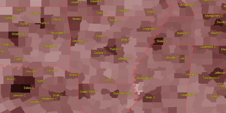
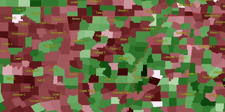
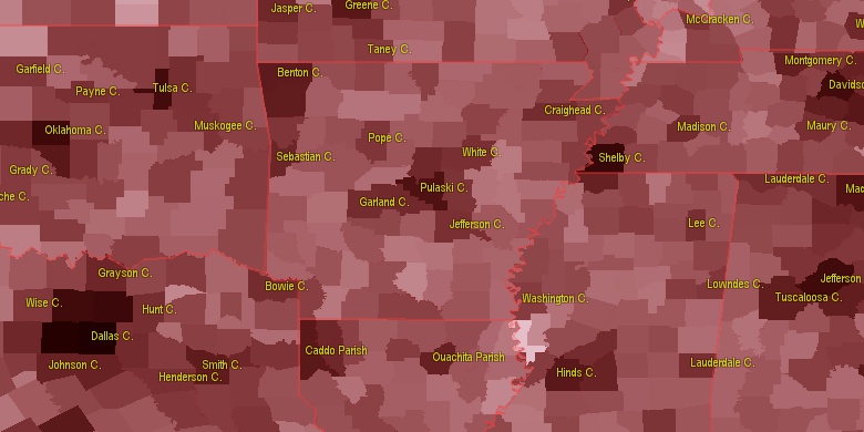
Estimated population for 2014[1]. Population density is in p./sq.mi [4]. Changes are for period 2010-2015. Value is %/year. Boundary lines are approx. 2012 [5]. Click on flag to hide it.
Population • Density • Changes • Legends • Position

[1850-1860] +6.6 %/yr
[1860-1870] +2.43 %/yr
[1870-1880] +5.58 %/yr
[1880-1890] +2.66 %/yr
[1890-1900] +2.36 %/yr
[1900-1910] +1.47 %/yr
[1910-1920] -0.26 %/yr
[1920-1930] -1.84 %/yr
[1930-1940] -0.16 %/yr
[1940-1950] -3.92 %/yr
[1950-1960] -1.62 %/yr
[1960-1970] +1.75 %/yr
[1970-1980] +1.83 %/yr
[1980-1990] +0.42 %/yr
[1990-2000] +1.75 %/yr
[2000-2005] +0.01 %/yr
[2005-2010] +0.97 %/yr
[2010-2014] -0.03 %/yr
Looking for settlements in Yell County? Visit this page: Settlements in Yell County, AR
Population of Yell County by age groups male (M) and female (F)[1b]
| Age Gr. | (M) | (F) | Total |
| 0 to 4 | 727 | 702 | 1,429 |
| 5 to 9 | 781 | 775 | 1,556 |
| 10 to 14 | 819 | 725 | 1,544 |
| 15 to 19 | 770 | 706 | 1,476 |
| 20 to 24 | 675 | 585 | 1,260 |
| 25 to 29 | 652 | 626 | 1,278 |
| 30 to 34 | 630 | 605 | 1,235 |
| 35 to 39 | 645 | 661 | 1,306 |
| 40 to 44 | 681 | 716 | 1,397 |
| 45 to 49 | 710 | 684 | 1,394 |
| 50 to 54 | 818 | 794 | 1,612 |
| 55 to 59 | 684 | 738 | 1,422 |
| 60 to 64 | 644 | 646 | 1,290 |
| 65 to 69 | 577 | 571 | 1,148 |
| 70 to 74 | 433 | 518 | 951 |
| 75 to 79 | 333 | 397 | 730 |
| 80 to 84 | 224 | 295 | 519 |
| 85+ | 122 | 282 | 404 |
Yell County resident population estimates by Sex, Race, and Hispanic Origin[1b]. For full list of abbrevations see: population.us/about page.
| Race | Male | Female | Total |
| WAC | 10403 | 10499 | 20,902 |
| WA | 10246 | 10366 | 20,612 |
| NH | 8783 | 9027 | 17,810 |
| NHWAC | 8369 | 8599 | 16,968 |
| NHWA | 8227 | 8479 | 16,706 |
| H | 2142 | 1999 | 4,141 |
| HWAC | 2034 | 1900 | 3,934 |
| HWA | 2019 | 1887 | 3,906 |
| BAC | 296 | 262 | 558 |
| NHBAC | 246 | 217 | 463 |
| BA | 240 | 210 | 450 |
| AAC | 189 | 209 | 398 |
| IAC | 196 | 195 | 391 |
| NHBA | 195 | 167 | 362 |
| NHAAC | 168 | 191 | 359 |
| AA | 162 | 185 | 347 |
| TOM | 163 | 147 | 310 |
| NHAA | 142 | 168 | 310 |
| NHIAC | 149 | 152 | 301 |
| NHTOM | 148 | 134 | 282 |
| IA | 105 | 111 | 216 |
| NHIA | 69 | 78 | 147 |
| HBAC | 50 | 45 | 95 |
| HIAC | 47 | 43 | 90 |
| HBA | 45 | 43 | 88 |
| HIA | 36 | 33 | 69 |
| HAAC | 21 | 18 | 39 |
| HAA | 20 | 17 | 37 |
| HTOM | 15 | 13 | 28 |
| NAC | 12 | 14 | 26 |
| NA | 9 | 7 | 16 |
| HNAC | 7 | 7 | 14 |
| HNA | 7 | 6 | 13 |
| NHNAC | 5 | 7 | 12 |
| NHNA | 2 | 1 | 3 |
• Saline County population
48.1 mi,  120°
120°
• Garland County
32.5 mi,  152°
152°
• Pope County
38.3 mi,  34°
34°
• Johnson County
39.9 mi,  355°
355°
• Logan County
23.3 mi,  310°
310°
• Conway County
44.6 mi,  65°
65°
• Franklin County
44.5 mi,  322°
322°
• Scott County
38.3 mi,  255°
255°
• Perry County
27.5 mi,  97°
97°
• Montgomery County
34.4 mi,  204°
204°
[0] Calculated by population.us from last known population growth rate, not official data.
[1] County population - 2014, archived from the original, retrieved 02/23/2016
[1b] Annual County Resident Population Estimates by Age, Sex, Race, and Hispanic Origin, (used only data for 2014) archived from the original, retrieved 02/23/2016
[2] County population - 2000-2010, archived from the original, retrieved 02/23/2016
[3] Population of States and Counties of the United States: 1790 to 1992, PDF, 15 Mb, census.gov, retrieved 02/23/2016
[4] County area, latitude longitude data, retrieved 02/23/2016
[5] County boundaries, CSV files on boundaries.us, retrived 03/18/2016
*Pope, Scott, Hot Spring; Conway Arkansas Notes
Page generated in 0.01 seconds© 2016 population.us | Terms of use | Contact