Last official estimated population of Placer County was 350,214 (year 2014)[1]. This was 0.11% of total US population and 0.9% of total California state population. Area of Placer County is 1,502.2 mi² (=3890.7 km²), in this year population density was 233.13 p/mi². If population growth rate would be same as in period 2010-2014 (+0.13%/yr), Placer County population in 2026 would be 355,615 [0].
Historical population of Placer County for period 1860-2014 [1] , [2] , [3]:
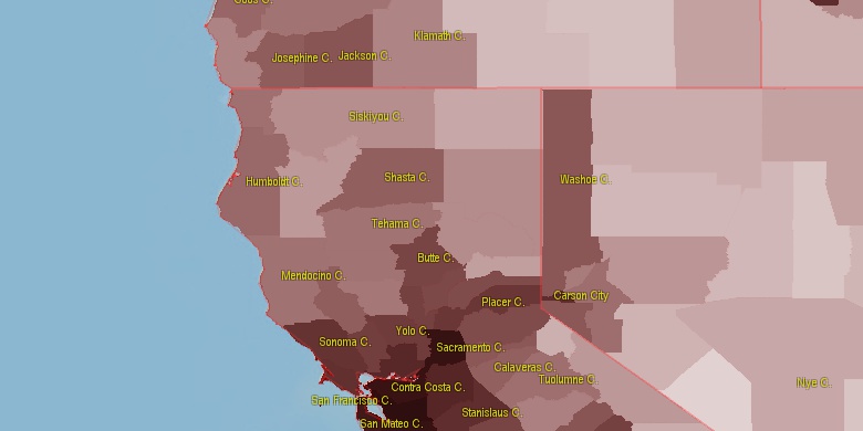
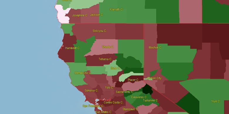
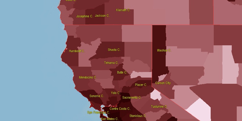
Estimated population for 2014[1]. Population density is in p./sq.mi [4]. Changes are for period 2010-2015. Value is %/year. Boundary lines are approx. 2012 [5]. Click on flag to hide it.
Population • Density • Changes • Legends • Position

[1860-1870] -1.54 %/yr
[1870-1880] +2.28 %/yr
[1880-1890] +0.59 %/yr
[1890-1900] +0.44 %/yr
[1900-1910] +1.45 %/yr
[1910-1920] +0.19 %/yr
[1920-1930] +2.79 %/yr
[1930-1940] +1.4 %/yr
[1940-1950] +4.01 %/yr
[1950-1960] +3.19 %/yr
[1960-1970] +3.09 %/yr
[1970-1980] +4.25 %/yr
[1980-1990] +3.95 %/yr
[1990-2000] +3.69 %/yr
[2000-2005] +4.73 %/yr
[2005-2010] +2.18 %/yr
[2010-2014] +0.13 %/yr
Looking for settlements in Placer County? Visit this page: Settlements in Placer County, CA
Population of Placer County by age groups male (M) and female (F)[1b]
| Age Gr. | (M) | (F) | Total |
| 0 to 4 | 10006 | 10063 | 20,069 |
| 5 to 9 | 12086 | 11698 | 23,784 |
| 10 to 14 | 13094 | 12418 | 25,512 |
| 15 to 19 | 12527 | 11794 | 24,321 |
| 20 to 24 | 10686 | 10074 | 20,760 |
| 25 to 29 | 9833 | 9453 | 19,286 |
| 30 to 34 | 10922 | 11018 | 21,940 |
| 35 to 39 | 11083 | 11434 | 22,517 |
| 40 to 44 | 12089 | 12755 | 24,844 |
| 45 to 49 | 12524 | 13136 | 25,660 |
| 50 to 54 | 13496 | 14161 | 27,657 |
| 55 to 59 | 12402 | 13413 | 25,815 |
| 60 to 64 | 10939 | 12351 | 23,290 |
| 65 to 69 | 10047 | 11440 | 21,487 |
| 70 to 74 | 7313 | 8628 | 15,941 |
| 75 to 79 | 5314 | 6274 | 11,588 |
| 80 to 84 | 3665 | 4706 | 8,371 |
| 85+ | 3195 | 5657 | 8,852 |
Placer County resident population estimates by Sex, Race, and Hispanic Origin[1b]. For full list of abbrevations see: population.us/about page.
| Race | Male | Female | Total |
| WAC | 162813 | 170180 | 332,993 |
| NH | 156214 | 165307 | 321,521 |
| WA | 155986 | 163240 | 319,226 |
| NHWAC | 139846 | 147050 | 286,896 |
| NHWA | 134329 | 141392 | 275,721 |
| H | 25007 | 25166 | 50,173 |
| HWAC | 22967 | 23130 | 46,097 |
| HWA | 21657 | 21848 | 43,505 |
| AAC | 16109 | 18335 | 34,444 |
| NHAAC | 15132 | 17319 | 32,451 |
| AA | 12088 | 14315 | 26,403 |
| NHAA | 11601 | 13788 | 25,389 |
| TOM | 7307 | 7482 | 14,789 |
| NHTOM | 5899 | 6066 | 11,965 |
| BAC | 4918 | 4530 | 9,448 |
| IAC | 4076 | 4254 | 8,330 |
| NHBAC | 4220 | 3850 | 8,070 |
| BA | 3428 | 2940 | 6,368 |
| NHBA | 3000 | 2539 | 5,539 |
| NHIAC | 2435 | 2650 | 5,085 |
| IA | 1949 | 2038 | 3,987 |
| HIAC | 1641 | 1604 | 3,245 |
| HTOM | 1408 | 1416 | 2,824 |
| NAC | 1159 | 1188 | 2,347 |
| NHIA | 1027 | 1154 | 2,181 |
| HAAC | 977 | 1016 | 1,993 |
| NHNAC | 937 | 970 | 1,907 |
| HIA | 922 | 884 | 1,806 |
| HBAC | 698 | 680 | 1,378 |
| HAA | 487 | 527 | 1,014 |
| NA | 463 | 458 | 921 |
| HBA | 428 | 401 | 829 |
| NHNA | 358 | 368 | 726 |
| HNAC | 222 | 218 | 440 |
| HNA | 105 | 90 | 195 |
• Sacramento County population
53.8 mi,  218°
218°
• El Dorado County
21.6 mi,  152°
152°
• Nevada County
16.5 mi,  350°
350°
• Sutter County
52.7 mi,  268°
268°
• Yuba County
36 mi,  293°
293°
• Carson City
52.7 mi,  83°
83°
• Douglas County
60.8 mi,  100°
100°
• Amador County
42.9 mi,  175°
175°
• Sierra County
37.2 mi,  16°
16°
• Alpine County
58.3 mi,  121°
121°
[0] Calculated by population.us from last known population growth rate, not official data.
[1] County population - 2014, archived from the original, retrieved 02/23/2016
[1b] Annual County Resident Population Estimates by Age, Sex, Race, and Hispanic Origin, (used only data for 2014) archived from the original, retrieved 02/23/2016
[2] County population - 2000-2010, archived from the original, retrieved 02/23/2016
[3] Population of States and Counties of the United States: 1790 to 1992, PDF, 15 Mb, census.gov, retrieved 02/23/2016
[4] County area, latitude longitude data, retrieved 02/23/2016
[5] County boundaries, CSV files on boundaries.us, retrived 03/18/2016
*Yuba, Sutter California Notes
Page generated in 0.002 seconds© 2016 population.us | Terms of use | Contact