Last official estimated population of Ventura County was 825,353 (year 2014)[1]. This was 0.259% of total US population and 2.1% of total California state population. Area of Ventura County is 2,208.2 mi² (=5719.3 km²), in this year population density was 373.76 p/mi². If population growth rate would be same as in period 2010-2014 (+0.06%/yr), Ventura County population in 2026 would be 831,488 [0].
Historical population of Ventura County for period 1880-2014 [1] , [2] , [3]:
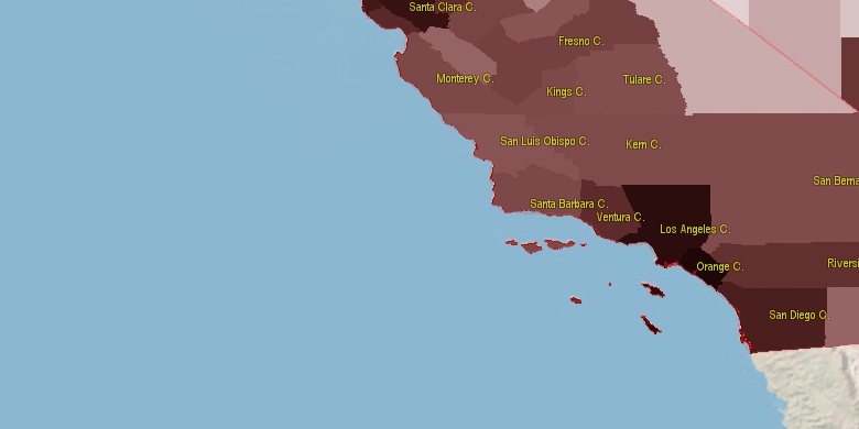
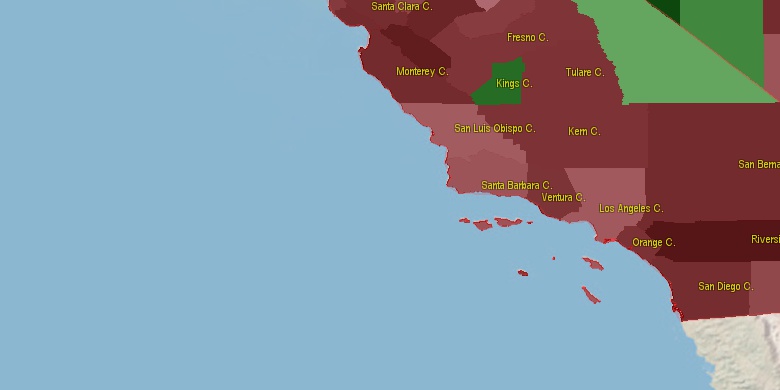
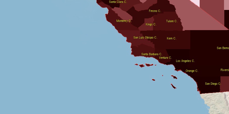
Estimated population for 2014[1]. Population density is in p./sq.mi [4]. Changes are for period 2010-2015. Value is %/year. Boundary lines are approx. 2012 [5]. Click on flag to hide it.
Population • Density • Changes • Legends • Position

[1880-1890] +7.1 %/yr
[1890-1900] +3.62 %/yr
[1900-1910] +2.48 %/yr
[1910-1920] +4.58 %/yr
[1920-1930] +6.71 %/yr
[1930-1940] +2.4 %/yr
[1940-1950] +5.1 %/yr
[1950-1960] +5.68 %/yr
[1960-1970] +6.57 %/yr
[1970-1980] +3.46 %/yr
[1980-1990] +2.37 %/yr
[1990-2000] +1.19 %/yr
[2000-2005] +1.06 %/yr
[2005-2010] +0.72 %/yr
[2010-2014] +0.06 %/yr
Looking for settlements in Ventura County? Visit this page: Settlements in Ventura County, CA
Population of Ventura County by age groups male (M) and female (F)[1b]
| Age Gr. | (M) | (F) | Total |
| 0 to 4 | 27376 | 26479 | 53,855 |
| 5 to 9 | 28913 | 27967 | 56,880 |
| 10 to 14 | 29203 | 28512 | 57,715 |
| 15 to 19 | 30468 | 28785 | 59,253 |
| 20 to 24 | 31399 | 29905 | 61,304 |
| 25 to 29 | 28804 | 26492 | 55,296 |
| 30 to 34 | 27788 | 26501 | 54,289 |
| 35 to 39 | 25589 | 26113 | 51,702 |
| 40 to 44 | 27450 | 27801 | 55,251 |
| 45 to 49 | 28625 | 29233 | 57,858 |
| 50 to 54 | 30489 | 31763 | 62,252 |
| 55 to 59 | 28439 | 29584 | 58,023 |
| 60 to 64 | 22816 | 24684 | 47,500 |
| 65 to 69 | 18306 | 20088 | 38,394 |
| 70 to 74 | 12539 | 14525 | 27,064 |
| 75 to 79 | 8416 | 10635 | 19,051 |
| 80 to 84 | 6221 | 8268 | 14,489 |
| 85+ | 5710 | 10292 | 16,002 |
Ventura County resident population estimates by Sex, Race, and Hispanic Origin[1b]. For full list of abbrevations see: population.us/about page.
| Race | Male | Female | Total |
| WAC | 368993 | 374292 | 743,285 |
| WA | 356331 | 361184 | 717,515 |
| NH | 239438 | 251489 | 490,927 |
| NHWAC | 202008 | 209769 | 411,777 |
| NHWA | 193438 | 200842 | 394,280 |
| H | 179113 | 176138 | 355,251 |
| HWAC | 166985 | 164523 | 331,508 |
| HWA | 162893 | 160342 | 323,235 |
| AAC | 36459 | 41789 | 78,248 |
| NHAAC | 32870 | 38137 | 71,007 |
| AA | 29248 | 34383 | 63,631 |
| NHAA | 27268 | 32400 | 59,668 |
| TOM | 13725 | 14215 | 27,940 |
| BAC | 12981 | 12290 | 25,271 |
| IAC | 12590 | 12400 | 24,990 |
| NHTOM | 9352 | 9749 | 19,101 |
| BA | 9914 | 9012 | 18,926 |
| NHBAC | 9595 | 8805 | 18,400 |
| HIAC | 9152 | 8645 | 17,797 |
| IA | 8131 | 7670 | 15,801 |
| NHBA | 7424 | 6488 | 13,912 |
| HIA | 6897 | 6354 | 13,251 |
| HTOM | 4373 | 4466 | 8,839 |
| HAAC | 3589 | 3652 | 7,241 |
| NHIAC | 3438 | 3755 | 7,193 |
| HBAC | 3386 | 3485 | 6,871 |
| NAC | 2517 | 2580 | 5,097 |
| HBA | 2490 | 2524 | 5,014 |
| HAA | 1980 | 1983 | 3,963 |
| NHNAC | 1649 | 1688 | 3,337 |
| NHIA | 1234 | 1316 | 2,550 |
| NA | 1202 | 1163 | 2,365 |
| HNAC | 868 | 892 | 1,760 |
| NHNA | 722 | 694 | 1,416 |
| HNA | 480 | 469 | 949 |
• Los Angeles County population
51 mi,  102°
102°
• San Diego County
163.9 mi,  124°
124°
• Orange County
90.9 mi, 121°
• San Bernardino County
171.4 mi,  78°
78°
• Fresno County
168.5 mi,  349°
349°
• Kern County
72 mi,  18°
18°
• Tulare County
130.7 mi,  8°
8°
• Santa Barbara County
53.1 mi,  283°
283°
• San Luis Obispo County
102.9 mi,  313°
313°
• Kings County
124.5 mi,  341°
341°
[0] Calculated by population.us from last known population growth rate, not official data.
[1] County population - 2014, archived from the original, retrieved 02/23/2016
[1b] Annual County Resident Population Estimates by Age, Sex, Race, and Hispanic Origin, (used only data for 2014) archived from the original, retrieved 02/23/2016
[2] County population - 2000-2010, archived from the original, retrieved 02/23/2016
[3] Population of States and Counties of the United States: 1790 to 1992, PDF, 15 Mb, census.gov, retrieved 02/23/2016
[4] County area, latitude longitude data, retrieved 02/23/2016
[5] County boundaries, CSV files on boundaries.us, retrived 03/18/2016
*Santa Barbara; San Luis Obispo, Kern California Notes
Page generated in 0.002 seconds© 2016 population.us | Terms of use | Contact