Last official estimated population of Yuma County was 10,016 (year 2014)[1]. This was 0.003% of total US population and 0.2% of total Colorado state population. Area of Yuma County is 2,368.7 mi² (=6134.9 km²), in this year population density was 4.23 p/mi². If population growth rate would be same as in period 2010-2014 (-0.07%/yr), Yuma County population in 2026 would be 9,935 [0].
Historical population of Yuma County for period 1890-2014 [1] , [2] , [3]:
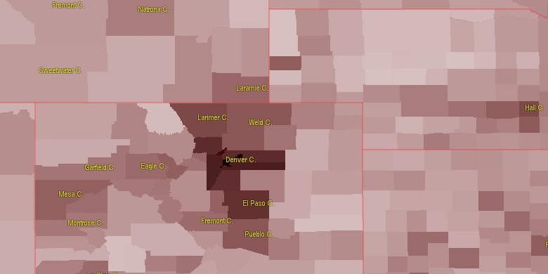
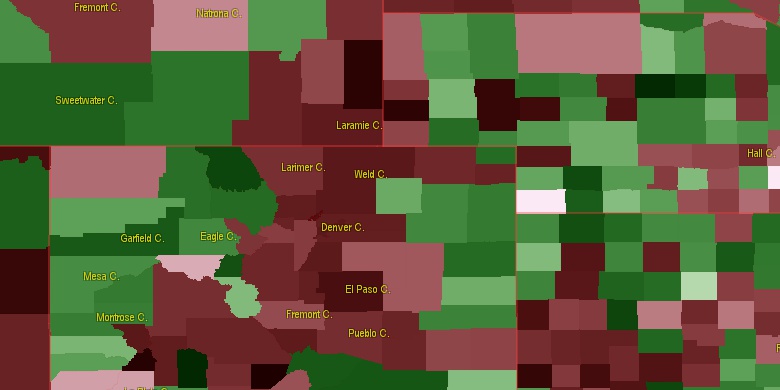
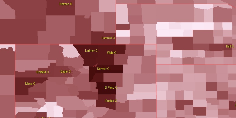
Estimated population for 2014[1]. Population density is in p./sq.mi [4]. Changes are for period 2010-2015. Value is %/year. Boundary lines are approx. 2012 [5]. Click on flag to hide it.
Population • Density • Changes • Legends • Position

[1890-1900] -3.98 %/yr
[1900-1910] +17.26 %/yr
[1910-1920] +5.04 %/yr
[1920-1930] -0.21 %/yr
[1930-1940] -1.17 %/yr
[1940-1950] -1.11 %/yr
[1950-1960] -1.93 %/yr
[1960-1970] -0.42 %/yr
[1970-1980] +1.26 %/yr
[1980-1990] -0.78 %/yr
[1990-2000] +0.95 %/yr
[2000-2005] -0.17 %/yr
[2005-2010] +0.56 %/yr
[2010-2014] -0.07 %/yr
Looking for settlements in Yuma County? Visit this page: Settlements in Yuma County, CO
Population of Yuma County by age groups male (M) and female (F)[1b]
| Age Gr. | (M) | (F) | Total |
| 0 to 4 | 403 | 365 | 768 |
| 5 to 9 | 353 | 434 | 787 |
| 10 to 14 | 378 | 337 | 715 |
| 15 to 19 | 354 | 318 | 672 |
| 20 to 24 | 296 | 272 | 568 |
| 25 to 29 | 294 | 287 | 581 |
| 30 to 34 | 331 | 297 | 628 |
| 35 to 39 | 285 | 242 | 527 |
| 40 to 44 | 317 | 287 | 604 |
| 45 to 49 | 327 | 290 | 617 |
| 50 to 54 | 335 | 349 | 684 |
| 55 to 59 | 355 | 315 | 670 |
| 60 to 64 | 284 | 317 | 601 |
| 65 to 69 | 234 | 282 | 516 |
| 70 to 74 | 187 | 222 | 409 |
| 75 to 79 | 150 | 169 | 319 |
| 80 to 84 | 126 | 137 | 263 |
| 85+ | 89 | 184 | 273 |
Yuma County resident population estimates by Sex, Race, and Hispanic Origin[1b]. For full list of abbrevations see: population.us/about page.
| Race | Male | Female | Total |
| WAC | 4986 | 5020 | 10,006 |
| WA | 4953 | 4977 | 9,930 |
| NH | 3914 | 4052 | 7,966 |
| NHWAC | 3859 | 4005 | 7,864 |
| NHWA | 3837 | 3973 | 7,810 |
| H | 1184 | 1052 | 2,236 |
| HWAC | 1127 | 1015 | 2,142 |
| HWA | 1116 | 1004 | 2,120 |
| IAC | 62 | 60 | 122 |
| IA | 46 | 39 | 85 |
| TOM | 35 | 44 | 79 |
| AAC | 26 | 41 | 67 |
| BAC | 46 | 16 | 62 |
| NHIAC | 26 | 36 | 62 |
| HIAC | 36 | 24 | 60 |
| NHTOM | 24 | 33 | 57 |
| AA | 21 | 31 | 52 |
| NHBAC | 34 | 13 | 47 |
| HIA | 30 | 17 | 47 |
| NHAAC | 16 | 27 | 43 |
| NHIA | 16 | 22 | 38 |
| BA | 31 | 5 | 36 |
| NHAA | 11 | 19 | 30 |
| NHBA | 24 | 3 | 27 |
| NAC | 13 | 11 | 24 |
| HAAC | 10 | 14 | 24 |
| HTOM | 11 | 11 | 22 |
| HAA | 10 | 12 | 22 |
| NA | 12 | 8 | 20 |
| HNAC | 10 | 7 | 17 |
| HNA | 10 | 6 | 16 |
| HBAC | 12 | 3 | 15 |
| HBA | 7 | 2 | 9 |
| NHNAC | 3 | 4 | 7 |
| NHNA | 2 | 2 | 4 |
• Logan County population
61.3 mi,  325°
325°
• Kit Carson County
49 mi,  191°
191°
• Sherman County
58.4 mi,  140°
140°
• Washington County
41.7 mi,  266°
266°
• Phillips County
41.2 mi,  5°
5°
• Chase County
53.1 mi,  46°
46°
• Perkins County
72.5 mi,  35°
35°
• Cheyenne County
39.6 mi,  111°
111°
• Sedgwick County
60.3 mi,  3°
3°
• Dundy County
41.1 mi,  72°
72°
[0] Calculated by population.us from last known population growth rate, not official data.
[1] County population - 2014, archived from the original, retrieved 02/23/2016
[1b] Annual County Resident Population Estimates by Age, Sex, Race, and Hispanic Origin, (used only data for 2014) archived from the original, retrieved 02/23/2016
[2] County population - 2000-2010, archived from the original, retrieved 02/23/2016
[3] Population of States and Counties of the United States: 1790 to 1992, PDF, 15 Mb, census.gov, retrieved 02/23/2016
[4] County area, latitude longitude data, retrieved 02/23/2016
[5] County boundaries, CSV files on boundaries.us, retrived 03/18/2016
*Weld Colorado Notes
Page generated in 0.013 seconds© 2016 population.us | Terms of use | Contact