Last official estimated population of Bristol County was 549,076 (year 2014)[1]. This was 0.172% of total US population and 8.1% of total Massachusetts state population. Area of Bristol County is 691.2 mi² (=1790.3 km²), in this year population density was 794.35 p/mi². If population growth rate would be same as in period 2010-2014 (+0.04%/yr), Bristol County population in 2026 would be 551,456 [0].
Historical population of Bristol County for period 1790-2014 [1] , [2] , [3]:
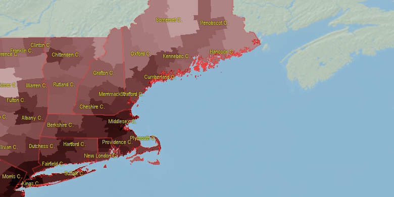
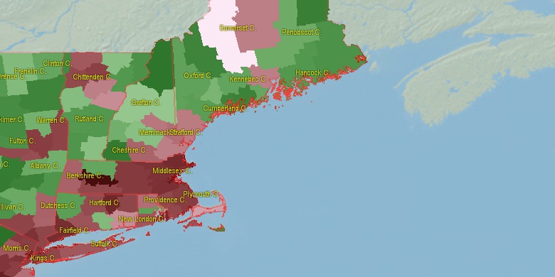
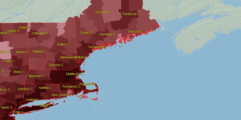
Estimated population for 2014[1]. Population density is in p./sq.mi [4]. Changes are for period 2010-2015. Value is %/year. Boundary lines are approx. 2012 [5]. Click on flag to hide it.
Population • Density • Changes • Legends • Position

[1790-1800] +0.66 %/yr
[1800-1810] +0.93 %/yr
[1810-1820] +0.96 %/yr
[1820-1830] +1.94 %/yr
[1830-1840] +1.95 %/yr
[1840-1850] +2.39 %/yr
[1850-1860] +2.1 %/yr
[1860-1870] +0.93 %/yr
[1870-1880] +3.06 %/yr
[1880-1890] +2.98 %/yr
[1890-1900] +3.06 %/yr
[1900-1910] +2.37 %/yr
[1910-1920] +1.2 %/yr
[1920-1930] +0.15 %/yr
[1930-1940] +0 %/yr
[1940-1950] +0.45 %/yr
[1950-1960] +0.43 %/yr
[1960-1970] +1.09 %/yr
[1970-1980] +0.66 %/yr
[1980-1990] +0.65 %/yr
[1990-2000] +0.55 %/yr
[2000-2005] +0.4 %/yr
[2005-2010] +0.1 %/yr
[2010-2014] +0.04 %/yr
Looking for settlements in Bristol County? Visit this page: Settlements in Bristol County, MA
Population of Bristol County by age groups male (M) and female (F)[1b]
| Age Gr. | (M) | (F) | Total |
| 0 to 4 | 14864 | 14165 | 29,029 |
| 5 to 9 | 16457 | 15958 | 32,415 |
| 10 to 14 | 17385 | 16890 | 34,275 |
| 15 to 19 | 18660 | 18000 | 36,660 |
| 20 to 24 | 19425 | 18801 | 38,226 |
| 25 to 29 | 17027 | 17402 | 34,429 |
| 30 to 34 | 16528 | 16986 | 33,514 |
| 35 to 39 | 15989 | 16933 | 32,922 |
| 40 to 44 | 18162 | 19194 | 37,356 |
| 45 to 49 | 20420 | 21156 | 41,576 |
| 50 to 54 | 21305 | 22177 | 43,482 |
| 55 to 59 | 19498 | 20731 | 40,229 |
| 60 to 64 | 15857 | 17343 | 33,200 |
| 65 to 69 | 13251 | 14914 | 28,165 |
| 70 to 74 | 9155 | 10995 | 20,150 |
| 75 to 79 | 6095 | 7836 | 13,931 |
| 80 to 84 | 4232 | 6683 | 10,915 |
| 85+ | 4261 | 9459 | 13,720 |
Bristol County resident population estimates by Sex, Race, and Hispanic Origin[1b]. For full list of abbrevations see: population.us/about page.
| Race | Male | Female | Total |
| NH | 249182 | 266512 | 515,694 |
| WAC | 247159 | 263888 | 511,047 |
| WA | 242179 | 258714 | 500,893 |
| NHWAC | 231552 | 248317 | 479,869 |
| NHWA | 227479 | 244099 | 471,578 |
| H | 19389 | 19111 | 38,500 |
| BAC | 16243 | 16265 | 32,508 |
| HWAC | 15607 | 15571 | 31,178 |
| HWA | 14700 | 14615 | 29,315 |
| NHBAC | 13322 | 13208 | 26,530 |
| BA | 13030 | 12852 | 25,882 |
| NHBA | 10830 | 10561 | 21,391 |
| AAC | 7048 | 7826 | 14,874 |
| NHAAC | 6830 | 7589 | 14,419 |
| AA | 5732 | 6516 | 12,248 |
| NHAA | 5612 | 6382 | 11,994 |
| TOM | 5452 | 5699 | 11,151 |
| NHTOM | 4463 | 4654 | 9,117 |
| IAC | 3373 | 3189 | 6,562 |
| HBAC | 2921 | 3057 | 5,978 |
| HBA | 2200 | 2291 | 4,491 |
| NHIAC | 1851 | 1982 | 3,833 |
| IA | 1894 | 1568 | 3,462 |
| HIAC | 1522 | 1207 | 2,729 |
| HIA | 1226 | 902 | 2,128 |
| HTOM | 989 | 1045 | 2,034 |
| NHIA | 668 | 666 | 1,334 |
| NAC | 613 | 636 | 1,249 |
| NHNAC | 405 | 445 | 850 |
| NA | 284 | 274 | 558 |
| HAAC | 218 | 237 | 455 |
| HNAC | 208 | 191 | 399 |
| NHNA | 130 | 150 | 280 |
| HNA | 154 | 124 | 278 |
| HAA | 120 | 134 | 254 |
• Suffolk County population
40.6 mi,  5°
5°
• Norfolk County
29.7 mi,  350°
350°
• Providence County
26.5 mi,  288°
288°
• Plymouth County
24.4 mi,  47°
47°
• Barnstable County
45.5 mi,  85°
85°
• Kent County
25.7 mi,  257°
257°
• Washington County
36.2 mi,  228°
228°
• Newport County
19.6 mi,  210°
210°
• Bristol County
10.7 mi,  253°
253°
• Dukes County
32.3 mi,  141°
141°
[0] Calculated by population.us from last known population growth rate, not official data.
[1] County population - 2014, archived from the original, retrieved 02/23/2016
[1b] Annual County Resident Population Estimates by Age, Sex, Race, and Hispanic Origin, (used only data for 2014) archived from the original, retrieved 02/23/2016
[2] County population - 2000-2010, archived from the original, retrieved 02/23/2016
[3] Population of States and Counties of the United States: 1790 to 1992, PDF, 15 Mb, census.gov, retrieved 02/23/2016
[4] County area, latitude longitude data, retrieved 02/23/2016
[5] County boundaries, CSV files on boundaries.us, retrived 03/18/2016
Page generated in 0.004 seconds© 2016 population.us | Terms of use | Contact