Last official estimated population of New Hanover County was 203,335 (year 2014)[1]. This was 0.064% of total US population and 2% of total North Carolina state population. Area of New Hanover County is 328.4 mi² (=850.6 km²), in this year population density was 619.15 p/mi². If population growth rate would be same as in period 2010-2014 (+0.08%/yr), New Hanover County population in 2026 would be 205,352 [0].
Historical population of New Hanover County for period 1790-2014 [1] , [2] , [3]:
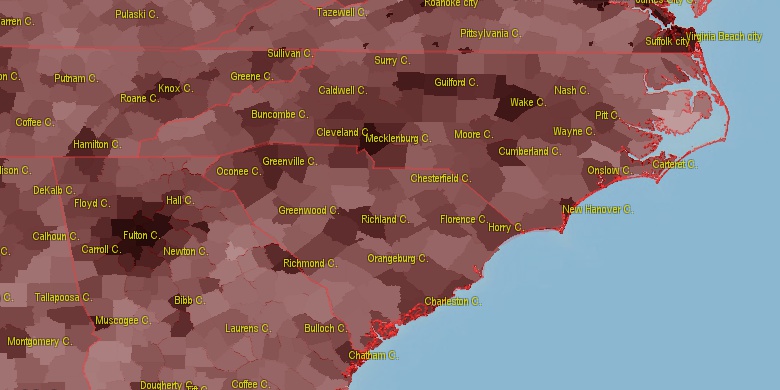
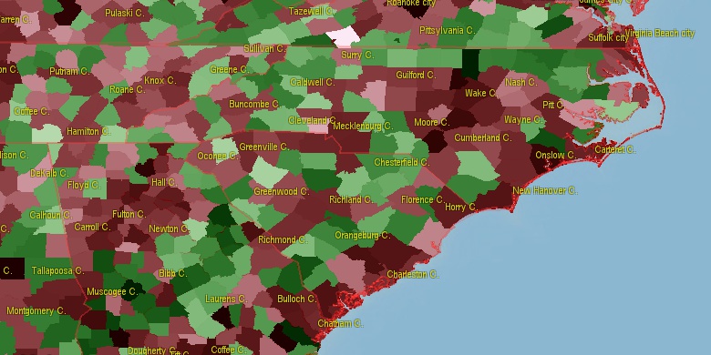
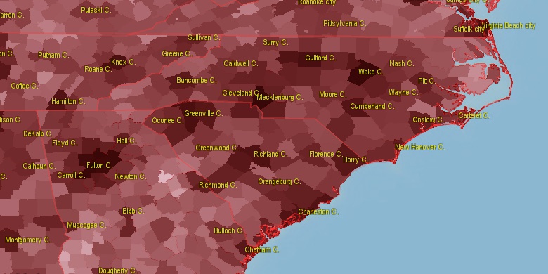
Estimated population for 2014[1]. Population density is in p./sq.mi [4]. Changes are for period 2010-2015. Value is %/year. Boundary lines are approx. 2012 [5]. Click on flag to hide it.
Population • Density • Changes • Legends • Position

[1790-1800] +0.33 %/yr
[1800-1810] +4.97 %/yr
[1810-1820] -0.54 %/yr
[1820-1830] +0.09 %/yr
[1830-1840] +1.96 %/yr
[1840-1850] +2.87 %/yr
[1850-1860] +2.08 %/yr
[1860-1870] +2.57 %/yr
[1870-1880] -2.66 %/yr
[1880-1890] +1.18 %/yr
[1890-1900] +0.71 %/yr
[1900-1910] +2.19 %/yr
[1910-1920] +2.4 %/yr
[1920-1930] +0.57 %/yr
[1930-1940] +1.09 %/yr
[1940-1950] +2.81 %/yr
[1950-1960] +1.26 %/yr
[1960-1970] +1.47 %/yr
[1970-1980] +2.23 %/yr
[1980-1990] +1.52 %/yr
[1990-2000] +2.91 %/yr
[2000-2005] +2.95 %/yr
[2005-2010] +1.8 %/yr
[2010-2014] +0.08 %/yr
Looking for settlements in New Hanover County? Visit this page: Settlements in New Hanover County, NC
Population of New Hanover County by age groups male (M) and female (F)[1b]
| Age Gr. | (M) | (F) | Total |
| 0 to 4 | 5667 | 5770 | 11,437 |
| 5 to 9 | 6188 | 5866 | 12,054 |
| 10 to 14 | 5992 | 5703 | 11,695 |
| 15 to 19 | 6561 | 7181 | 13,742 |
| 20 to 24 | 10440 | 10843 | 21,283 |
| 25 to 29 | 7249 | 7285 | 14,534 |
| 30 to 34 | 7444 | 7441 | 14,885 |
| 35 to 39 | 6723 | 6765 | 13,488 |
| 40 to 44 | 7044 | 7163 | 14,207 |
| 45 to 49 | 6563 | 6714 | 13,277 |
| 50 to 54 | 6757 | 7441 | 14,198 |
| 55 to 59 | 6394 | 7586 | 13,980 |
| 60 to 64 | 6071 | 7272 | 13,343 |
| 65 to 69 | 5437 | 6482 | 11,919 |
| 70 to 74 | 3781 | 4524 | 8,305 |
| 75 to 79 | 2534 | 3099 | 5,633 |
| 80 to 84 | 1650 | 2348 | 3,998 |
| 85+ | 1389 | 2931 | 4,320 |
New Hanover County resident population estimates by Sex, Race, and Hispanic Origin[1b]. For full list of abbrevations see: population.us/about page.
| Race | Male | Female | Total |
| NH | 97904 | 106778 | 204,682 |
| WAC | 86820 | 92843 | 179,663 |
| WA | 84977 | 90892 | 175,869 |
| NHWAC | 81588 | 88060 | 169,648 |
| NHWA | 79955 | 86351 | 166,306 |
| BAC | 15805 | 17969 | 33,774 |
| NHBAC | 15261 | 17331 | 32,592 |
| BA | 14719 | 16787 | 31,506 |
| NHBA | 14306 | 16304 | 30,610 |
| H | 5980 | 5636 | 11,616 |
| HWAC | 5232 | 4783 | 10,015 |
| HWA | 5022 | 4541 | 9,563 |
| AAC | 2004 | 2374 | 4,378 |
| TOM | 2100 | 2240 | 4,340 |
| NHAAC | 1877 | 2269 | 4,146 |
| NHTOM | 1849 | 1956 | 3,805 |
| AA | 1382 | 1722 | 3,104 |
| NHAA | 1309 | 1674 | 2,983 |
| IAC | 1308 | 1418 | 2,726 |
| NHIAC | 996 | 1086 | 2,082 |
| IA | 572 | 624 | 1,196 |
| HBAC | 544 | 638 | 1,182 |
| HBA | 413 | 483 | 896 |
| NHIA | 385 | 438 | 823 |
| HIAC | 312 | 332 | 644 |
| HTOM | 251 | 284 | 535 |
| NAC | 244 | 265 | 509 |
| HIA | 187 | 186 | 373 |
| NHNAC | 192 | 158 | 350 |
| NA | 134 | 149 | 283 |
| HAAC | 127 | 105 | 232 |
| HNAC | 52 | 107 | 159 |
| NHNA | 100 | 55 | 155 |
| HNA | 34 | 94 | 128 |
| HAA | 73 | 48 | 121 |
• Horry County population
66 mi,  253°
253°
• Onslow County
45.6 mi,  27°
27°
• Brunswick County
22.6 mi,  244°
244°
• Sampson County
63 mi,  333°
333°
• Lenoir County
74.6 mi,  10°
10°
• Duplin County
52.4 mi,  356°
356°
• Columbus County
44.3 mi,  277°
277°
• Pender County
23.1 mi, 357°
• Bladen County
47.7 mi,  306°
306°
• Jones County
65.9 mi, 26°
[0] Calculated by population.us from last known population growth rate, not official data.
[1] County population - 2014, archived from the original, retrieved 02/23/2016
[1b] Annual County Resident Population Estimates by Age, Sex, Race, and Hispanic Origin, (used only data for 2014) archived from the original, retrieved 02/23/2016
[2] County population - 2000-2010, archived from the original, retrieved 02/23/2016
[3] Population of States and Counties of the United States: 1790 to 1992, PDF, 15 Mb, census.gov, retrieved 02/23/2016
[4] County area, latitude longitude data, retrieved 02/23/2016
[5] County boundaries, CSV files on boundaries.us, retrived 03/18/2016
Page generated in 0.007 seconds© 2016 population.us | Terms of use | Contact