Last official estimated population of Humboldt County was 16,603 (year 2014)[1]. This was 0.005% of total US population and 0.6% of total Nevada state population. Area of Humboldt County is 9,657.9 mi² (=25013.7 km²), in this year population density was 1.72 p/mi². If population growth rate would be same as in period 2010-2014 (+0.11%/yr), Humboldt County population in 2026 would be 16,830 [0].
Historical population of Humboldt County for period 1860-2014 [1] , [2] , [3]:
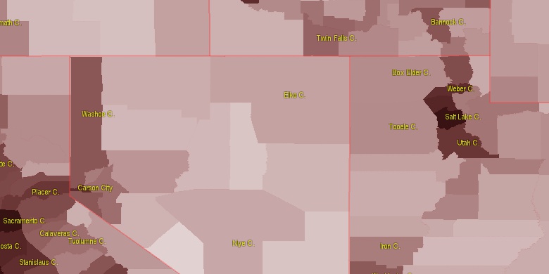
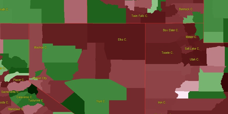
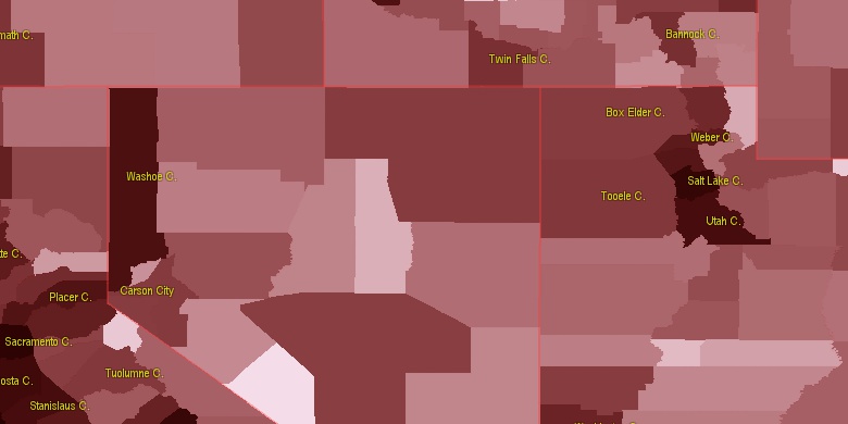
Estimated population for 2014[1]. Population density is in p./sq.mi [4]. Changes are for period 2010-2015. Value is %/year. Boundary lines are approx. 2012 [5]. Click on flag to hide it.
Population • Density • Changes • Legends • Position

[1860-1870] +47.24 %/yr
[1870-1880] +6.15 %/yr
[1880-1890] -0.13 %/yr
[1890-1900] +2.66 %/yr
[1900-1910] +4.34 %/yr
[1910-1920] -5.83 %/yr
[1920-1930] +0.14 %/yr
[1930-1940] +2.25 %/yr
[1940-1950] +0.2 %/yr
[1950-1960] +1.67 %/yr
[1960-1970] +1.11 %/yr
[1970-1980] +4 %/yr
[1980-1990] +3.13 %/yr
[1990-2000] +2.27 %/yr
[2000-2005] -1.32 %/yr
[2005-2010] +1.9 %/yr
[2010-2014] +0.11 %/yr
Looking for settlements in Humboldt County? Visit this page: Settlements in Humboldt County, NV
Population of Humboldt County by age groups male (M) and female (F)[1b]
| Age Gr. | (M) | (F) | Total |
| 0 to 4 | 664 | 681 | 1,345 |
| 5 to 9 | 668 | 678 | 1,346 |
| 10 to 14 | 643 | 624 | 1,267 |
| 15 to 19 | 611 | 559 | 1,170 |
| 20 to 24 | 600 | 499 | 1,099 |
| 25 to 29 | 627 | 580 | 1,207 |
| 30 to 34 | 638 | 529 | 1,167 |
| 35 to 39 | 549 | 493 | 1,042 |
| 40 to 44 | 603 | 515 | 1,118 |
| 45 to 49 | 594 | 510 | 1,104 |
| 50 to 54 | 651 | 600 | 1,251 |
| 55 to 59 | 673 | 594 | 1,267 |
| 60 to 64 | 568 | 491 | 1,059 |
| 65 to 69 | 387 | 319 | 706 |
| 70 to 74 | 248 | 247 | 495 |
| 75 to 79 | 159 | 156 | 315 |
| 80 to 84 | 79 | 104 | 183 |
| 85+ | 62 | 76 | 138 |
Humboldt County resident population estimates by Sex, Race, and Hispanic Origin[1b]. For full list of abbrevations see: population.us/about page.
| Race | Male | Female | Total |
| WAC | 8322 | 7642 | 15,964 |
| WA | 8115 | 7438 | 15,553 |
| NH | 6702 | 6075 | 12,777 |
| NHWAC | 6164 | 5611 | 11,775 |
| NHWA | 6020 | 5466 | 11,486 |
| H | 2322 | 2180 | 4,502 |
| HWAC | 2158 | 2031 | 4,189 |
| HWA | 2095 | 1972 | 4,067 |
| IAC | 571 | 533 | 1,104 |
| IA | 444 | 414 | 858 |
| NHIAC | 418 | 398 | 816 |
| NHIA | 340 | 317 | 657 |
| TOM | 228 | 227 | 455 |
| BAC | 192 | 140 | 332 |
| NHTOM | 158 | 163 | 321 |
| HIAC | 153 | 135 | 288 |
| AAC | 132 | 133 | 265 |
| NHBAC | 152 | 95 | 247 |
| NHAAC | 103 | 107 | 210 |
| BA | 135 | 67 | 202 |
| HIA | 104 | 97 | 201 |
| AA | 76 | 86 | 162 |
| NHBA | 111 | 40 | 151 |
| HTOM | 70 | 64 | 134 |
| NHAA | 61 | 70 | 131 |
| NAC | 52 | 46 | 98 |
| HBAC | 40 | 45 | 85 |
| NHNAC | 33 | 38 | 71 |
| HAAC | 29 | 26 | 55 |
| HBA | 24 | 27 | 51 |
| NA | 26 | 23 | 49 |
| HAA | 15 | 16 | 31 |
| NHNA | 12 | 19 | 31 |
| HNAC | 19 | 8 | 27 |
| HNA | 14 | 4 | 18 |
• Washoe County population
92.5 mi,  239°
239°
• Lassen County
138.7 mi,  249°
249°
• Malheur County
125.9 mi,  12°
12°
• Churchill County
129.4 mi,  183°
183°
• Owyhee County
128 mi,  51°
51°
• Modoc County
134.7 mi,  275°
275°
• Harney County
122.6 mi,  338°
338°
• Pershing County
68.5 mi,  192°
192°
• Lander County
118.6 mi,  151°
151°
• Eureka County
138.6 mi,  135°
135°
[0] Calculated by population.us from last known population growth rate, not official data.
[1] County population - 2014, archived from the original, retrieved 02/23/2016
[1b] Annual County Resident Population Estimates by Age, Sex, Race, and Hispanic Origin, (used only data for 2014) archived from the original, retrieved 02/23/2016
[2] County population - 2000-2010, archived from the original, retrieved 02/23/2016
[3] Population of States and Counties of the United States: 1790 to 1992, PDF, 15 Mb, census.gov, retrieved 02/23/2016
[4] County area, latitude longitude data, retrieved 02/23/2016
[5] County boundaries, CSV files on boundaries.us, retrived 03/18/2016
Page generated in 0.015 seconds© 2016 population.us | Terms of use | Contact