Last official estimated population of Butte County was 219,924 (year 2014)[1]. This was 0.069% of total US population and 0.6% of total California state population. Area of Butte County is 1,677.1 mi² (=4343.8 km²), in this year population density was 131.13 p/mi². If population growth rate would be same as in period 2010-2014 (-0.01%/yr), Butte County population in 2026 would be 219,696 [0].
Historical population of Butte County for period 1850-2014 [1] , [2] , [3]:
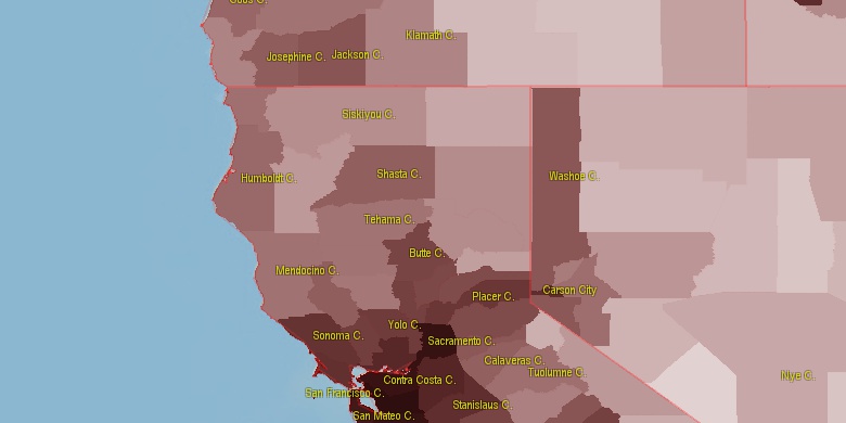
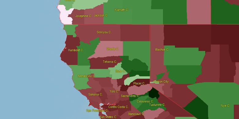
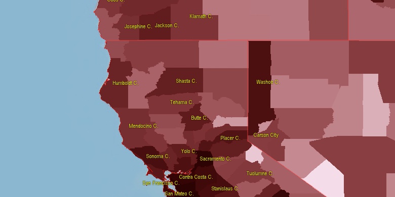
Estimated population for 2014[1]. Population density is in p./sq.mi [4]. Changes are for period 2010-2015. Value is %/year. Boundary lines are approx. 2012 [5]. Click on flag to hide it.
Population • Density • Changes • Legends • Position

[1850-1860] +12.98 %/yr
[1860-1870] -0.6 %/yr
[1870-1880] +5.08 %/yr
[1880-1890] -0.43 %/yr
[1890-1900] -0.47 %/yr
[1900-1910] +4.78 %/yr
[1910-1920] +0.96 %/yr
[1920-1930] +1.28 %/yr
[1930-1940] +2.31 %/yr
[1940-1950] +4.25 %/yr
[1950-1960] +2.37 %/yr
[1960-1970] +2.2 %/yr
[1970-1980] +3.5 %/yr
[1980-1990] +2.39 %/yr
[1990-2000] +1.1 %/yr
[2000-2005] +1.12 %/yr
[2005-2010] +0.48 %/yr
[2010-2014] -0.01 %/yr
Looking for settlements in Butte County? Visit this page: Settlements in Butte County, CA
Population of Butte County by age groups male (M) and female (F)[1b]
| Age Gr. | (M) | (F) | Total |
| 0 to 4 | 6202 | 5847 | 12,049 |
| 5 to 9 | 6418 | 6212 | 12,630 |
| 10 to 14 | 6515 | 6268 | 12,783 |
| 15 to 19 | 8076 | 7868 | 15,944 |
| 20 to 24 | 14074 | 13283 | 27,357 |
| 25 to 29 | 7202 | 6308 | 13,510 |
| 30 to 34 | 6968 | 6448 | 13,416 |
| 35 to 39 | 5865 | 5690 | 11,555 |
| 40 to 44 | 5855 | 5665 | 11,520 |
| 45 to 49 | 5854 | 6017 | 11,871 |
| 50 to 54 | 6657 | 7098 | 13,755 |
| 55 to 59 | 7235 | 7653 | 14,888 |
| 60 to 64 | 7057 | 7697 | 14,754 |
| 65 to 69 | 6076 | 6564 | 12,640 |
| 70 to 74 | 4035 | 4666 | 8,701 |
| 75 to 79 | 2858 | 3477 | 6,335 |
| 80 to 84 | 2081 | 2620 | 4,701 |
| 85+ | 2078 | 3754 | 5,832 |
Butte County resident population estimates by Sex, Race, and Hispanic Origin[1b]. For full list of abbrevations see: population.us/about page.
| Race | Male | Female | Total |
| WAC | 100250 | 102881 | 203,131 |
| WA | 95927 | 98358 | 194,285 |
| NH | 93404 | 96188 | 189,592 |
| NHWAC | 84216 | 87624 | 171,840 |
| NHWA | 80729 | 84039 | 164,768 |
| H | 17702 | 16947 | 34,649 |
| HWAC | 16034 | 15257 | 31,291 |
| HWA | 15198 | 14319 | 29,517 |
| AAC | 6792 | 6596 | 13,388 |
| NHAAC | 6431 | 6235 | 12,666 |
| AA | 5271 | 5081 | 10,352 |
| IAC | 4899 | 5116 | 10,015 |
| NHAA | 5079 | 4902 | 9,981 |
| TOM | 4624 | 4832 | 9,456 |
| NHTOM | 3713 | 3831 | 7,544 |
| NHIAC | 3258 | 3441 | 6,699 |
| BAC | 3456 | 3048 | 6,504 |
| IA | 2756 | 2817 | 5,573 |
| NHBAC | 2986 | 2495 | 5,481 |
| BA | 2218 | 1745 | 3,963 |
| NHIA | 1726 | 1789 | 3,515 |
| NHBA | 1931 | 1403 | 3,334 |
| HIAC | 1641 | 1675 | 3,316 |
| HIA | 1030 | 1028 | 2,058 |
| HTOM | 911 | 1001 | 1,912 |
| NAC | 715 | 721 | 1,436 |
| NHNAC | 564 | 564 | 1,128 |
| HBAC | 470 | 553 | 1,023 |
| HAAC | 361 | 361 | 722 |
| HBA | 287 | 342 | 629 |
| NA | 310 | 302 | 612 |
| NHNA | 226 | 224 | 450 |
| HAA | 192 | 179 | 371 |
| HNAC | 151 | 157 | 308 |
| HNA | 84 | 78 | 162 |
• Placer County population
62.8 mi,  131°
131°
• Yolo County
70 mi,  193°
193°
• Nevada County
51.1 mi,  119°
119°
• Sutter County
43.9 mi, 187°
• Yuba County
30.9 mi,  153°
153°
• Tehama County
46.1 mi,  313°
313°
• Glenn County
42.8 mi,  264°
264°
• Colusa County
47.8 mi,  225°
225°
• Plumas County
47 mi,  61°
61°
• Sierra County
57.8 mi,  96°
96°
[0] Calculated by population.us from last known population growth rate, not official data.
[1] County population - 2014, archived from the original, retrieved 02/23/2016
[1b] Annual County Resident Population Estimates by Age, Sex, Race, and Hispanic Origin, (used only data for 2014) archived from the original, retrieved 02/23/2016
[2] County population - 2000-2010, archived from the original, retrieved 02/23/2016
[3] Population of States and Counties of the United States: 1790 to 1992, PDF, 15 Mb, census.gov, retrieved 02/23/2016
[4] County area, latitude longitude data, retrieved 02/23/2016
[5] County boundaries, CSV files on boundaries.us, retrived 03/18/2016
Page generated in 0.003 seconds© 2016 population.us | Terms of use | Contact