Last official estimated population of Flathead County was 90,902 (year 2014)[1]. This was 0.029% of total US population and 8.8% of total Montana state population. Area of Flathead County is 5,256.0 mi² (=13613 km²), in this year population density was 17.29 p/mi². If population growth rate would be same as in period 2010-2014 (-0.01%/yr), Flathead County population in 2026 would be 90,824 [0].
Historical population of Flathead County for period 1900-2014 [1] , [2] , [3]:
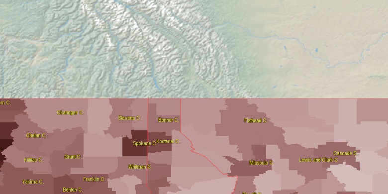
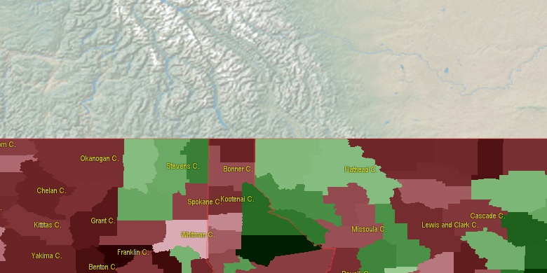
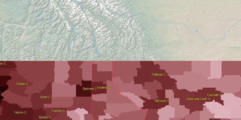
Estimated population for 2014[1]. Population density is in p./sq.mi [4]. Changes are for period 2010-2015. Value is %/year. Boundary lines are approx. 2012 [5]. Click on flag to hide it.
Population • Density • Changes • Legends • Position

[1900-1910] +7.2 %/yr
[1910-1920] +1.46 %/yr
[1920-1930] -1.22 %/yr
[1930-1940] +2.37 %/yr
[1940-1950] +2.64 %/yr
[1950-1960] +0.46 %/yr
[1960-1970] +1.81 %/yr
[1970-1980] +2.79 %/yr
[1980-1990] +1.31 %/yr
[1990-2000] +2.32 %/yr
[2000-2005] +2.26 %/yr
[2005-2010] +1.76 %/yr
[2010-2014] -0.01 %/yr
Looking for settlements in Flathead County? Visit this page: Settlements in Flathead County, MT
Population of Flathead County by age groups male (M) and female (F)[1b]
| Age Gr. | (M) | (F) | Total |
| 0 to 4 | 2870 | 2664 | 5,534 |
| 5 to 9 | 3103 | 2804 | 5,907 |
| 10 to 14 | 3165 | 2889 | 6,054 |
| 15 to 19 | 2978 | 2713 | 5,691 |
| 20 to 24 | 2504 | 2557 | 5,061 |
| 25 to 29 | 2547 | 2685 | 5,232 |
| 30 to 34 | 2887 | 3017 | 5,904 |
| 35 to 39 | 2825 | 2754 | 5,579 |
| 40 to 44 | 2802 | 2768 | 5,570 |
| 45 to 49 | 2845 | 2878 | 5,723 |
| 50 to 54 | 3406 | 3625 | 7,031 |
| 55 to 59 | 3791 | 4138 | 7,929 |
| 60 to 64 | 3679 | 3739 | 7,418 |
| 65 to 69 | 2976 | 2898 | 5,874 |
| 70 to 74 | 1980 | 2045 | 4,025 |
| 75 to 79 | 1383 | 1386 | 2,769 |
| 80 to 84 | 813 | 984 | 1,797 |
| 85+ | 688 | 1138 | 1,826 |
Flathead County resident population estimates by Sex, Race, and Hispanic Origin[1b]. For full list of abbrevations see: population.us/about page.
| Race | Male | Female | Total |
| WAC | 46048 | 46374 | 92,422 |
| NH | 45952 | 46438 | 92,390 |
| WA | 45033 | 45364 | 90,397 |
| NHWAC | 44887 | 45251 | 90,138 |
| NHWA | 43985 | 44328 | 88,313 |
| IAC | 1329 | 1354 | 2,683 |
| H | 1290 | 1244 | 2,534 |
| NHIAC | 1157 | 1208 | 2,365 |
| HWAC | 1161 | 1123 | 2,284 |
| TOM | 1054 | 1060 | 2,114 |
| HWA | 1048 | 1036 | 2,084 |
| NHTOM | 934 | 964 | 1,898 |
| IA | 638 | 649 | 1,287 |
| AAC | 531 | 661 | 1,192 |
| NHAAC | 500 | 624 | 1,124 |
| NHIA | 550 | 572 | 1,122 |
| AA | 292 | 411 | 703 |
| NHAA | 286 | 397 | 683 |
| BAC | 332 | 323 | 655 |
| NHBAC | 291 | 289 | 580 |
| BA | 179 | 158 | 337 |
| HIAC | 172 | 146 | 318 |
| NHBA | 159 | 144 | 303 |
| HTOM | 120 | 96 | 216 |
| NAC | 100 | 90 | 190 |
| HIA | 88 | 77 | 165 |
| NHNAC | 87 | 76 | 163 |
| NA | 46 | 40 | 86 |
| HBAC | 41 | 34 | 75 |
| NHNA | 38 | 33 | 71 |
| HAAC | 31 | 37 | 68 |
| HBA | 20 | 14 | 34 |
| HNAC | 13 | 14 | 27 |
| HAA | 6 | 14 | 20 |
| HNA | 8 | 7 | 15 |
• Missoula County population
89.3 mi,  175°
175°
• Lake County
46.4 mi, 181°
• Lincoln County
66.6 mi,  284°
284°
• Glacier County
55.7 mi,  60°
60°
• Shoshone County
108 mi,  231°
231°
• Sanders County
64.7 mi, 233°
• Pondera County
84.6 mi,  93°
93°
• Teton County
88.7 mi,  112°
112°
• Toole County
108.7 mi,  77°
77°
• Mineral County
92.9 mi,  210°
210°
[0] Calculated by population.us from last known population growth rate, not official data.
[1] County population - 2014, archived from the original, retrieved 02/23/2016
[1b] Annual County Resident Population Estimates by Age, Sex, Race, and Hispanic Origin, (used only data for 2014) archived from the original, retrieved 02/23/2016
[2] County population - 2000-2010, archived from the original, retrieved 02/23/2016
[3] Population of States and Counties of the United States: 1790 to 1992, PDF, 15 Mb, census.gov, retrieved 02/23/2016
[4] County area, latitude longitude data, retrieved 02/23/2016
[5] County boundaries, CSV files on boundaries.us, retrived 03/18/2016
*Missoula, Deer Lodge Montana Notes
Page generated in 0.007 seconds© 2016 population.us | Terms of use | Contact